Cynthia Kennedy Henzel
The history of maps spans millennia, from ancient cave etchings to modern digital representations, reflecting humanity's evolving understanding of the world.
The development of maps is a long and complex history, beginning with early human attempts to represent their surroundings. These earliest forms, often found in cave paintings or carvings on natural materials, are difficult to definitively identify as maps due to imprecise definitions and the ambiguity of ancient artifacts. Over time, civilizations like the Babylonians, Greeks, and Chinese began producing more sophisticated maps, initially focusing on local terrain before gradually expanding to represent larger regions and eventually the entire world.
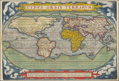
The ancient Greeks, in particular, made significant contributions to cartography. Influenced by concepts of the Earth as a disk surrounded by an ocean, thinkers like Anaximander and Hecataeus developed world maps. These early representations, though lacking precise scales and often based on mythological or limited geographical knowledge, laid the groundwork for later advancements. The use of projection from a globe became important for mapping larger areas, addressing the distortions inherent in flat representations. Modern technology, from aerial photography to satellite imagery and online tools, has dramatically increased the accessibility and accuracy of maps.
Early Cartographic Representations
The origins of mapmaking are shrouded in uncertainty, with various artifacts proposed as the earliest examples. These include prehistoric carvings on mammoth tusks and bones, cave etchings possibly depicting the night sky, and rock formations with symbolic markings. Some of these early representations, dating back as far as 25,000 BC, may have depicted local landscapes, celestial bodies, or even spiritual concepts. The precise definition of a "map" remains fluid, making definitive identification challenging. The Ségognole 3 rock shelter in France holds a potential three-dimensional representation of the surrounding landscape, dating to around 12,000-11,000 BC, while a Neolithic village plan from Çatalhöyük remains debated as a true map.
Ancient Near Eastern and Greek Contributions
Ancient civilizations in the Near East, notably Babylon, developed advanced surveying techniques for mapmaking. Babylonian clay tablets from the 25th-24th centuries BC depict river valleys and land plots with cuneiform labels, showing hills, rivers, and cities. The Babylonian World Map, circa 600 BC, offered a symbolic rather than literal view of the world. Phoenician explorers, through their extensive seafaring, may have contributed to the understanding of a spherical Earth. In Ancient Greece, figures like Homer and Hesiod influenced early geographical conceptions. Anaximander is credited with creating one of the earliest known world maps, depicting Earth as a cylinder, while Hecataeus of Miletus later produced an improved version, portraying Earth as a disk surrounded by Ocean, with Greece at its center. These maps, often lacking scale and based on limited knowledge, served to accompany geographical texts and aid understanding.
Evolution Towards Modern Cartography
The understanding of Earth's curvature became crucial for mapping larger regions and the world. Classical Greek scholars began using projection methods derived from a model globe to manage the distortions inherent in flat maps. This approach was essential for accurately representing vast areas. Advancements in transportation, aerial surveillance, and particularly satellite imagery in modern times have revolutionized mapmaking. These technologies have made it possible to document previously inaccessible regions with unprecedented detail. The advent of free online services like Google Earth has further democratized access to accurate global maps, making them more readily available to the public than ever before.
Books by Cynthia Kennedy Henzel
2 free public domain books · Read online or download