Christopher Mcintosh Christopher Mcintosh
The Piri Reis map, compiled in 1513, is a surviving fragment of a world map known for its detailed depiction of South America and unusual Caribbean arrangement, referencing lost Columbus maps.
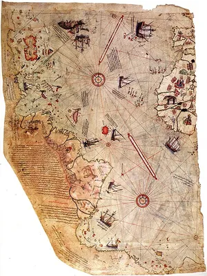
The Piri Reis map, created by an Ottoman admiral in 1513, is a fragment of a larger world map that has survived to the present day. This portolan chart, notable for its navigational aids like compass roses and wind networks instead of latitude and longitude lines, features extensive annotations in Ottoman Turkish. Its depiction of South America was considered detailed for its time, though the representation of the Caribbean combined elements of Cuba and Central America, suggesting influence from a lost map by Christopher Columbus that erroneously placed Cuba on the Asian mainland.
The map's creation involved a synthesis of various sources, including twenty charts, Arabic texts, and a map attributed to Columbus. Its visual style blended Islamic miniature traditions with European cartographic elements, and it included depictions of legendary creatures, which scholars suggest deviated from traditional Islamic views of the world's edges. The map has been subject to scholarly debate regarding its exact sources and the identification of certain geographical features, with some interpretations suggesting possible knowledge of lands not officially discovered by 1513, though such claims lack definitive evidence. The surviving portion was rediscovered in 1929 at the Topkapı Palace and garnered significant attention.
Compilation and Rediscovery
The Piri Reis map was compiled in 1513 by the Ottoman admiral and cartographer Piri Reis. Approximately one-third of this world map survives today, housed in the Topkapı Palace in Istanbul. After the Ottoman conquest of Egypt in 1517, Piri Reis presented the map to Sultan Selim I. Its whereabouts remained unknown for centuries until a fragment was rediscovered in 1929 during the conversion of the Topkapı Palace into a museum. The discovery of this fragment, which contained a partial copy of a lost map by Christopher Columbus, generated considerable international interest. The map's rediscovery was facilitated by a project to preserve ancient manuscripts, leading to its identification by scholar Paul E. Kahle, who recognized its connection to Columbus's voyages.
Cartographic Features and Sources
As a portolan chart, the Piri Reis map emphasizes navigational accuracy through compass roses and a windrose network, rather than a grid of longitude and latitude. Its extensive notes are primarily in Ottoman Turkish, written with the Arabic alphabet. The map's depiction of South America is notably detailed for the era, while the Caribbean's arrangement suggests a composite based on a lost Columbus map that conflated Cuba with the Asian mainland and Hispaniola with Japan, reflecting Columbus's misconception of reaching Asia. The map's visual style is distinct, incorporating influences from Islamic miniature painting, which was unusual for its inclusion of non-Muslim sources and its depiction of legendary creatures, potentially challenging medieval Islamic notions of an impassable world.
Interpretations and Scholarly Debate
The Piri Reis map has been the subject of various interpretations and scholarly debates. Discussions revolve around the precise number and nature of the source maps used in its creation, with Piri Reis himself listing twenty charts, Jaferiyes, an Arabic map of India, four Portuguese maps of Asia, and a map by Columbus. The exact identification of some of these sources, particularly the Jaferiyes and the 'mappae mundi,' remains unclear, with potential links to Ptolemy or medieval Islamic cartography. Some authors have pointed to visual similarities with parts of the Americas not officially charted by 1513, leading to speculation about its cartographic accuracy and potential for representing unknown lands. However, definitive textual or historical evidence to support the representation of lands south of present-day Cananéia is absent, and a 20th-century hypothesis linking the southern landmass to an ice-free Antarctic coast has been disproven.
Key Ideas
- Portolan chart navigation using compass roses and windrose networks
- Synthesis of European discoveries with traditional Islamic cartographic perspectives
- Influence of lost maps, particularly from Christopher Columbus, on early 16th-century cartography
- Debate over the sources and accuracy of early world maps
Books by Christopher Mcintosh Christopher Mcintosh
0 free public domain books · Read online or download